


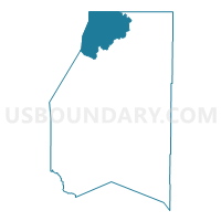
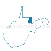
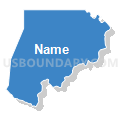
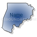
Voting District 1, Preston County, West Virginia
About
Outline

Summary
| Unique Area Identifier | 691729 |
| Name | Voting District 1 |
| County | Preston County |
| State | West Virginia |
| Area (square miles) | 49.13 |
| Land Area (square miles) | 48.93 |
| Water Area (square miles) | 0.20 |
| % of Land Area | 99.60 |
| % of Water Area | 0.40 |
| Latitude of the Internal Point | 39.66561820 |
| Longtitude of the Internal Point | -79.71533690 |
Maps

Graphs
Select a template below for downloading or customizing gragh for Voting District 1, Preston County, West Virginia


Neighbors
Neighoring Voting District (by Name) Neighboring Voting District on the Map
- Voting District 2, Preston County, WV
- Voting District 4, Preston County, WV
- Voting District 77, Monongalia County, WV
- Voting District 79, Monongalia County, WV
- Voting District 82, Monongalia County, WV
- SPRINGHILL TWP DIST 01, Fayette County, PA
- WHARTON TWP DIST 02, Fayette County, PA
Top 10 Neighboring County Subdivision (by Population) Neighboring County Subdivision on the Map
- Eastern district, Monongalia County, WV (39,767)
- Second district, Preston County, WV (8,708)
- First district, Preston County, WV (6,635)
- Wharton township, Fayette County, PA (3,575)
- Springhill township, Fayette County, PA (2,907)
Top 10 Neighboring Place (by Population) Neighboring Place on the Map
Top 10 Neighboring Unified School District (by Population) Neighboring Unified School District on the Map
- Monongalia School District, WV (96,189)
- Preston County School District, WV (33,520)
- Albert Gallatin Area School District, PA (23,880)
- Uniontown Area School District, PA (23,820)
Top 10 Neighboring State Legislative District Lower Chamber (by Population) Neighboring State Legislative District Lower Chamber on the Map
- State House District 44, WV (89,802)
- State House District 51, PA (56,731)
- State House District 45, WV (22,068)
Top 10 Neighboring State Legislative District Upper Chamber (by Population) Neighboring State Legislative District Upper Chamber on the Map
- State Senate District 32, PA (225,580)
- State Senate District 13, WV (122,633)
- State Senate District 14, WV (121,969)
Top 10 Neighboring 111th Congressional District (by Population) Neighboring 111th Congressional District on the Map
Top 10 Neighboring Census Tract (by Population) Neighboring Census Tract on the Map
- Census Tract 9638, Preston County, WV (6,763)
- Census Tract 2631, Fayette County, PA (5,871)
- Census Tract 9639, Preston County, WV (3,811)
- Census Tract 2627.01, Fayette County, PA (3,575)
- Census Tract 117, Monongalia County, WV (3,348)
Top 10 Neighboring 5-Digit ZIP Code Tabulation Area (by Population) Neighboring 5-Digit ZIP Code Tabulation Area on the Map
- 26508, WV (29,170)
- 26525, WV (7,064)
- 15478, PA (6,446)
- 15437, PA (2,573)
- 26542, WV (2,547)
- 26519, WV (1,836)
- 15440, PA (349)